Westbrook 🇺🇸
-
Nautical Twilight begins:04:20 amSunrise:05:31 am
-
Sunset:07:46 pmNautical Twilight ends:08:56 pm
-
Moonrise:02:58 am
-
Moonset:01:05 pm
-
Moon over:08:01 am
-
Moon under:08:14 pm
-
Visibility:37%
-
 Third Quarter Moon
-
Distance to earth:365,112 kmProximity:95.3 %
Moon Phases for Westbrook
-
average Day
-
minor Time:01:58 am - 03:58 am
-
major Time:07:01 am - 09:01 am
-
minor Time:12:05 pm - 02:05 pm
-
major Time:
 07:14 pm -
09:14 pm
07:14 pm -
09:14 pm
Tide Clock
Tide Graph
Times
| Tide | Time | Height |
|---|---|---|
| high | 06:02 am | 9.12 ft |
| low | 12:35 pm | 0.43 ft |
| high | 06:53 pm | 8.5 ft |
| Date | Major Bite Times | Minor Bite Times | Sun | Moon | Moonphase | Tide Times |
|---|---|---|---|---|---|---|
|
Thu, 02 May
|
07:01 am -
09:01 am
07:14 pm -
09:14 pm
|
01:58 am -
03:58 am
12:05 pm -
02:05 pm
|
R: 05:31 am S: 07:46 pm |
R: 02:58 am S: 01:05 pm |
Third Quarter Moon |
high: 06:02 am
, 9.12 ft
, Coeff: 110
low: 12:35 pm
, 0.43 ft
high: 06:53 pm
, 8.5 ft
, Coeff: 97
|
|
Fri, 03 May
|
07:53 am -
09:53 am
08:04 pm -
10:04 pm
|
02:23 am -
04:23 am
01:23 pm -
03:23 pm
|
R: 05:30 am S: 07:47 pm |
R: 03:23 am S: 02:23 pm |
Waning Crescent |
low: 01:00 am
, 1.08 ft
high: 07:10 am
, 9.22 ft
, Coeff: 112
low: 01:38 pm
, 0.23 ft
high: 07:55 pm
, 9.06 ft
, Coeff: 109
|
|
Sat, 04 May
|
08:43 am -
10:43 am
08:54 pm -
10:54 pm
|
02:45 am -
04:45 am
02:42 pm -
04:42 pm
|
R: 05:28 am S: 07:48 pm |
R: 03:45 am S: 03:42 pm |
Waning Crescent |
low: 02:07 am
, 0.56 ft
high: 08:17 am
, 9.42 ft
, Coeff: 117
low: 02:37 pm
, -0.03 ft
high: 08:52 pm
, 9.71 ft
, Coeff: 123
|
|
Sun, 05 May
|
09:33 am -
11:33 am
09:44 pm -
11:44 pm
|
03:06 am -
05:06 am
04:01 pm -
06:01 pm
|
R: 05:27 am S: 07:49 pm |
R: 04:06 am S: 05:01 pm |
Waning Crescent |
low: 03:10 am
, -0.1 ft
high: 09:19 am
, 9.68 ft
, Coeff: 122
low: 03:32 pm
, -0.26 ft
high: 09:45 pm
, 10.33 ft
, Coeff: 136
|
|
Mon, 06 May
|
10:24 am -
12:24 pm
10:37 pm -
12:37 am
|
03:28 am -
05:28 am
05:21 pm -
07:21 pm
|
R: 05:26 am S: 07:50 pm |
R: 04:28 am S: 06:21 pm |
New Moon |
low: 04:07 am
, -0.75 ft
high: 10:17 am
, 9.91 ft
, Coeff: 127
low: 04:24 pm
, -0.43 ft
high: 10:36 pm
, 10.83 ft
, Coeff: 146
|
|
Tue, 07 May
|
11:18 am -
01:18 pm
11:03 pm -
01:03 am
|
03:53 am -
05:53 am
06:43 pm -
08:43 pm
|
R: 05:25 am S: 07:51 pm |
R: 04:53 am S: 07:43 pm |
New Moon |
low: 05:01 am
, -1.25 ft
high: 11:11 am
, 10.01 ft
, Coeff: 129
low: 05:14 pm
, -0.46 ft
high: 11:24 pm
, 11.12 ft
, Coeff: 152
|
|
Wed, 08 May
|
12:13 pm -
02:13 pm
11:54 pm -
01:54 am
|
04:22 am -
06:22 am
08:04 pm -
10:04 pm
|
R: 05:23 am S: 07:53 pm |
R: 05:22 am S: 09:04 pm |
New Moon |
low: 05:52 am
, -1.51 ft
high: 12:03 pm
, 9.94 ft
, Coeff: 128
low: 06:02 pm
, -0.33 ft
|


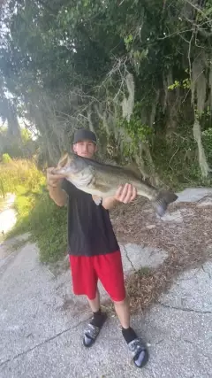
uploaded by: Lee Smith 1

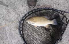
uploaded by: D2Turnt

uploaded by: PT Edward fisher

uploaded by: Charlie Pifer

uploaded by: Charlie Pifer

uploaded by: Charlie Pifer

uploaded by: Charlie Pifer

uploaded by: bariu

uploaded by: bariu

uploaded by: bariu
Best Fishing Spots in the greater Westbrook area
Wharf's or Jetties are good places to wet a line and meet other fishermen. They often produce a fresh feed of fish and are also great to catch bait fish. As they are often well lit, they also provide a good opportunity for night fishing. There are 10 wharf(s) in this area.
Wrights Wharf - 10km , Browns Wharf - 10km , Chandlers Wharf - 10km , Union Wharf - 10km , Cumberland Wharf - 10km , Custom House Wharf - 10km , Long Wharf - 10km , Hobsons Wharf - 10km , Engineers Wharf - 14km , Jones Wharf - 14km
Beaches and Bays are ideal places for land-based fishing. If the beach is shallow and the water is clear then twilight times are usually the best times, especially when they coincide with a major or minor fishing time. Often the points on either side of a beach are the best spots. Or if the beach is large then look for irregularities in the breaking waves, indicating sandbanks and holes. We found 7 beaches and bays in this area.
Willard Beach - 12km , West Shore Sandy Beach - 13km , Cliff House Beach - 13km , Big Beach - 14km , Little Beach - 14km , Pine Point Beach - 15km , Scarborough Beach - 15km
Harbours and Marinas can often times be productive fishing spots for land based fishing as their sheltered environment attracts a wide variety of bait fish. Similar to river mouths, harbour entrances are also great places to fish as lots of fish will move in and out with the rising and falling tides. There are 9 main harbours in this area.
Portland Bridge - 10km, Old Port - 10km, Portland Harbor - 11km, Channel Crossing Marina - 11km, Sunset Marina - 11km, Breakwater Marina - 12km, Spring Point Marina - 12km, Peaks Island Marina - 14km, Jones Landing Marina - 14km
We found a total of 100 potential fishing spots nearby Westbrook. Below you can find them organized on a map. Points, Headlands, Reefs, Islands, Channels, etc can all be productive fishing spots. As these are user submitted spots, there might be some errors in the exact location. You also need to cross check local fishing regulations. Some of the spots might be in or around marine reserves or other locations that cannot be fished. If you click on a location marker it will bring up some details and a quick link to google search, satellite maps and fishing times. Tip: Click/Tap on a new area to load more fishing spots.
Saccarappa Dam - 0km , Beaver Pond - 1km , Haskell Pond - 1km , Cumberland Dam - 2km , Capisic Pond - 5km , Riverton Bridge - 5km , Stroudwater Dam - 5km , Rye Pond (historical) - 6km , Clark Pond Dam - 7km , Mallison Falls Dam - 7km , Thompson Point - 7km , Back Cove - 8km , Veterans Memorial Bridge - 8km , Vaughans Bridge (historical) - 8km , Little Falls Dam - 8km , Highland Lake Dam - 8km , Turner Island - 9km , Tukey Bridge - 9km , Wrights Wharf - 10km , Portland Bridge - 10km , Old Port - 10km , Browns Wharf - 10km , Chandlers Wharf - 10km , Union Wharf - 10km , Martin Point Bridge - 10km , Martin Point - 10km , Cumberland Wharf - 10km , Custom House Wharf - 10km , Long Wharf - 10km , Gambo Falls Dam - 10km , Hobsons Wharf - 10km , Portland Harbor - 11km , Channel Crossing Marina - 11km , Mill Brook Dam - 11km , Mackworth Point - 11km , Mackworth Island - 11km , Loveitt Bridge - 11km , Sunset Marina - 11km , Fish Point - 11km , Highland Lake - 11km , Babbs Bridge - 12km , Winnocks Neck - 12km , Willard Beach - 12km , Breakwater Marina - 12km , Cushing Point - 12km , Duck Pond - 12km , Spring Point Marina - 12km , Spring Point - 12km , Simonton Cove - 12km , Hog Island Ledge - 12km , Plummer Island - 13km , Bartlett Point - 13km , Nonesuch Cove - 13km , The Brothers - 13km , Mussel Cove - 13km , West Shore Sandy Beach - 13km , Prince Point - 13km , Cliff House Beach - 13km , Danford Cove - 13km , Maiden Cove - 13km , Dundee Pond Dam - 13km , Little Diamond Island - 13km , Fort Scammel Point - 13km , Foxwells Bridge Brook Dam - 13km , House Island - 13km , Peaks Island Marina - 14km , Big Beach - 14km , Brackett Point - 14km , Nonesuch Point - 14km , City Point - 14km , Cushing Island - 14km , Echo Point - 14km , Rock Point - 14km , Engineers Wharf - 14km , Little Beach - 14km , Lamson Cove - 14km , Great Diamond Island - 14km , Jones Wharf - 14km , Jones Landing Marina - 14km , Seal Cove - 14km , Spring Cove - 14km , Spicers Cove - 14km , Indian Cove - 14km , Snake Pond - 14km , Ship Cove - 14km , Pine Point Beach - 15km , Peaks Island - 15km , Pond Cove - 15km , Otter Ponds - 15km , North Gorham Dam - 15km , Prouts Neck - 15km , Pumpkin Nob - 15km , Ram Island - 15km , Massacre Pond - 15km , Little Duck Pond - 15km , Scarborough Beach - 15km , Josiahs Cove - 15km , Hussey Sound - 15km , Whitehead - 15km , Torrington Point - 15km
Comments